Chuck & Honie's Mini-Tour of San Francisco
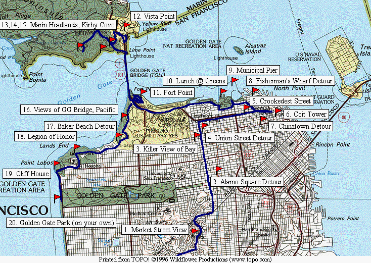
Overview map of the tour (193 KB)
Detail map, step 1 (272 KB)
Detail map, steps 2-11 (284 KB)
Detail map, steps 9-16 (225 KB)
Detail map, steps 17-20 (291 KB)
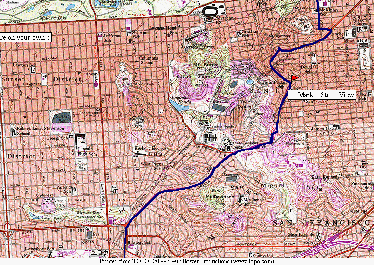
- Start by going North on Hwy 1 where it splits off from Hwy 280 as Hwy 280
heads over the hill toward downtown San Francisco. Go straight ahead
at the light, continuing on Junipero Serra Blvd. Bear right at the
light at the messy intersection of Sloat, Junipero Serra, Portal and
Portola. You should be on Portola, headed up the hill almost
directly toward Twin Peaks. After some meandering through the
neighborhoods, you come around the flank of Twin Peaks and before you
is a gorgeous view of San Francisco, with a convenient parking area
at which to stop.
- Continue down Portola as it turns into Market Street. You must go just past
Castro Street and turn hard left at the next intersection and circle
back to Castro/Divisadero. Continue straight on Divisadero past Fell
Street and turn right on Hayes Street to Alamo Square. This is
another wonderful view of the modern SF skyline set behind a row of
small Victorian houses often featured in postcards. You can get out
at Alamo Square to walk around the park and enjoy the view and
breeze.
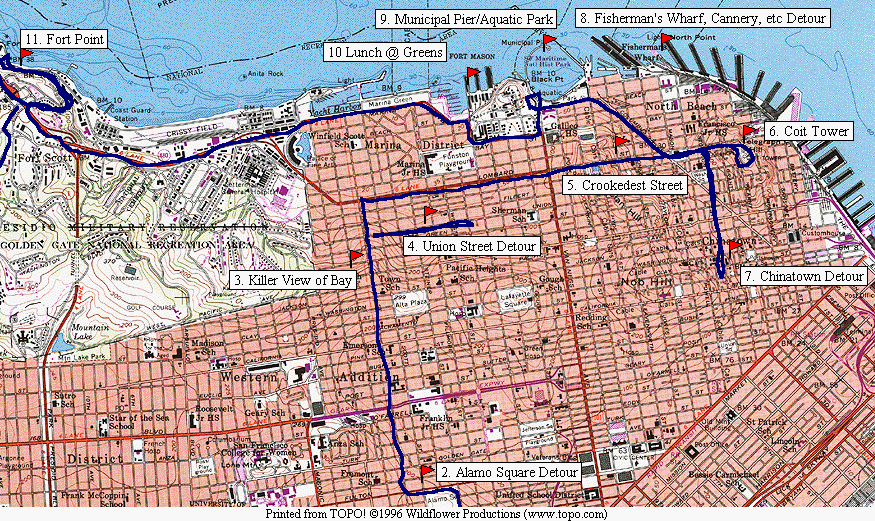
- Continue the journey North on Divisadero across Geary Street and up over
Pacific Heights. At the top of the hill (Broadway) the road drops
off in a classic SF hill and the view of the bay is spectacular (if
you can take your eyes off the drop-off beneath your wheels!).
- Near the bottom of the hill you pass Union Street, and a detour can be made
for shopping if you are so inclined. (Note that the parking is
difficult on Union Street, but there are two underground garages
available.)
- Turn right on Lombard Street, and follow it straight across Van Ness Street
and straight up the hill to Hyde Street. Cross Hyde Street (trying
to miss the passing cable cars) and proceed down the "Crookedest
Street in the World." You can stop here if you can find a parking
place. A good view can be had from the bottom of the crooked part,
and the parking is easier at the bottom.
- Continue straight down Lombard Street, across Columbus Ave. (which cuts
across at an angle) and proceed up the hill in front of you
(Telegraph Hill) to Coit Tower. Here there might be a wait for a
parking place at the top, and if you feel like walking instead of
waiting, you can park on the side streets and walk. However, the
wait is not usually too long, and the driver can stay with the car as
the line clears and let the passengers walk on ahead to enjoy the
view. Dont miss the great murals inside the tower itself.
- Come back down Telegraph Hill and if you want to take a detour to
Chinatown, turn left on Stockton, proceed down to Columbus. Turn
left on Columbus and proceed past Broadway to where Columbus turns
into Montgomery and turns slightly to the right. Park down in this
area or cut right on any side street to get closer to Grant Avenue.
(There is a parking garage under Portsmouth Square, between
Washington and Clay on Kearney.) You can go up to Grant Avenue and
walk up and down. An interesting side trip here is to walk over to
California Street and ride the cable car. There are often places
available on the cable car even at the intersection of California and
Grant, but you can always walk back down to California and Market to
wait in line. The ride goes up the California Street hill and all
the way to Van Ness, where you have to get off and re-mount for the
return trip.
- Reverse your direction to head northwest on Columbus Ave to Bay Street. (If
you didn't go into Chinatown, turn right off Lombard Street onto
Columbus Ave. and head northwest to Bay Street.) Here you can
continue straight into the Fisherman's Wharf area if you don't want to
walk back from the Municipal Pier.
- If you are going on to the Municipal Pier, turn left on Bay Street and
proceed west to Van Ness Ave., where you turn right towards the
parking area above and approaching the Municipal Pier at Aquatic
Park. Stop here and take a walk onto the pier for one of the most
wonderful views in the world. You get the Bay, the Bridge, Alcatraz,
Angel Island, and of course, San Francisco. You can also walk back
to Fisherman's Wharf, the Cannery, Ghirardelli Square, and Pier 39
and so forth if your legs can take it.
- Get back on Bay Street and proceed west to Laguna Street and turn north
(right) and enter the lower part of Fort Mason. Here you can park
and have a great lunch with a great view at Green's Restaurant. The
food is good, the view is great, and there is parking almost all the
time! This is a unique feature for most of the sightseeing places
so far on your tour!
- After lunch, leave Fort Mason on Marina Street, past the yacht clubs and
onto the elevated road headed toward the Golden Gate Bridge. Be
sure to stay in the right lane so that you can get off just before
the toll plaza, taking a right turn down the hill and another sharp
left turn to go toward Fort Point. You can stop anywhere along here
where you find a parking place and take in the view of the Golden
Gate Bridge. If the view seems familiar, maybe you saw it in the
great Alfred Hitchcock thriller, "Vertigo." Also proceed another
quarter mile to Fort Point for another great view of the bridge from
directly under the south end.
- Retrace your steps to the toll plaza and head over the bridge in the right
lane to the view area at Vista Point. Stop here for another great
view.
- Leave Vista Point heading immediately off to the right towards Sausalito.
(You can take a detour to Sausalito if you want, of course.) As you
leave Hwy 101, be prepared to turn sharply to the left under the
highway, through a tunnel back toward San Francisco. Now take the
right turn up the hill to the Marin Headlands. There is parking
here and there along the road, and all the views are great. A lot
of automobile ads are shot along these stretches of road, with the
bridge and city in the background.
- Soon after the first views of the bridge and ocean, there is a trail
(actually a fire road) heading to the left down the hill to Kirby
Cove. The trail is about a mile and a steady descent to the cove
itself. The view at Kirby Cove is also wonderful, but one must be
in pretty good condition to make the walk in comfort. Have some
good walking shoes if you decide to make this side trip.
- Proceed up the road for about a mile to several parking places (some with
benches for sitting) for a monster view of the Pacific, the Golden
Gate Bridge, the City, and so forth.
- Now head back down the headlands road to the bridge, and proceed back
across, staying in the right lane. Immediately after the tollbooth
turn right onto Lincoln Blvd and head West along the coast. Here
there are several places to stop and look over the scene.
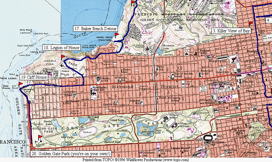
- One can take a detour to Baker Beach and a short walk to the beach. Ansel
Adams took one of his most famous pictures of the Golden Gate Bridge
from Baker Beach, and the view is worth a detour.
- Back on Lincoln Blvd, proceed on to the Palace of the Legion of Honor. One
can also stop anywhere along here to take in the views. The museum
is also worth a look if you have time, and features Rodin's "The
Thinker" in the entryway, visible without having to pay an entrance
fee.
- Leave Lincoln Park to the South on 34th Street and turn right on Geary
Street. Follow this West right on down to the top of the bluffs
overlooking Seal Rock. You can stop at the Cliff House or any of
the parking lots to take in the view of the Pacific.
- At the Cliff House, Geary turns south and becomes the Great Highway, and
one passes the end of Golden Gate Park. One can turn left into
Golden Gate Park for more sightseeing, or head straight South on the
Great Highway, turning left (east) on Sloat Ave and then right
(south) on 19th Ave. This leads right back to the intersection of
Junipero Serra, where the tour began. We hope you enjoyed it!
Return to my home page.